Major Projects Foundation and Inkfish Expedition Update
Expedition Solomon Islands 2025 is a 4-month scientific endeavour involving a team of oceanographers, marine scientists, and marine archaeologists. The Expedition is organised into five legs; the Inkfish team will lead Legs 2, 3 and 4 and focus on characterising the physical environment, biodiversity and ecology of mesophotic coral reefs and their influence on shallow reef ecosystems around Rennell Island, Solomon Islands. The Major Projects Foundation will lead legs 1 and 5 and will focus on surveying selected WWII ship and plane wrecks within the coastal waters of Guadalcanal, Central, and Western Provinces.
EXPEDITION LEG 1 & 5
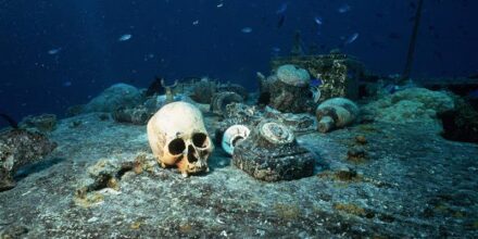
The Solomon Islands is home to over 200 WWII-era shipwrecks, with 118 classified as potentially polluting and 15 identified as high-risk Actively and Potentially Polluting Wrecks (APWs/PPWs). Today only limited information exists on the exact location, condition, or rates of deterioration of these sites, as well as the potential environmental risks they pose if left unmanaged.
Leg 1 and 5 of Expedition Solomons will utilise advanced mapping and imaging technologies to collect detailed and high-quality data on these ship and plane wrecks. Mapping efforts will employ multibeam echosounder (MBES) technology to create accurate, high-resolution bathymetric maps, providing essential information on the location of the wrecks. For more detailed, site-specific analysis, high-resolution photogrammetric imaging will be conducted using divers and submersibles. This technique will capture precise, three-dimensional visual data of the surveyed areas, enabling detailed assessments of the condition and structural integrity of wreck sites and UXO locations. Together, these methods will provide comprehensive datasets to support the Solomon Islands authorities and local communities in managing and preserving their underwater cultural heritage and protecting their marine environment.
EXPEDITION LEG 2, 3 & 4
Tropical reef ecosystems cover less than 1% of the Earth’s surface but support around 25% of marine biodiversity and provide vital resources for over 850 million people. Yet, most research has focused on shallow reefs (<30 m), leaving deeper mesophotic reefs (30–150 m) poorly understood where fewer comprehensive studies exist. These deeper reefs often host distinct and diverse coral communities, not just extensions of shallow systems, and may play a crucial role in reef resilience and biodiversity.
This expedition will address knowledge gaps around the location, health, and ecological role of mesophotic reefs. We will begin with broad-scale mapping of bathymetry and oceanographic conditions, followed by targeted high-resolution surveys using marine robotics and diver-based photogrammetry. Finally, we will conduct sampling across environmental gradients to capture shallow and mesophotic biodiversity. These efforts will observe mesophotic reef ecosystems in the Solomon Islands, laying the groundwork for improved understanding and management.

LEG 1 UPDATE: 24-31 MAY 2025
On the 14th of April, RV Hydra arrived into the Solomon Islands and over the next 39 days a rigorous schedule of submersible training and preparations was implemented to prepare for undertaking and supporting scientific operations. On the 24th of May the science team from the Major Projects Foundation arrived onboard to begin Leg 1 of the Expedition and begin their work surveying and assessing the WWII ship and plan wrecks around Central Province. Over the next two days, all equipment was assembled and checked with successful shakedown dives undertaken by the scientific dive team to survey the wrecks of two Japanese Kawanishi H6K “Mavis” flying boats in Tulagi.

The two submersibles aboard Hydra were also put to good use undertaking the first comprehensive video survey of the destroyer USS Aaron Ward also located in Tulagi. These submersible dives allowed the team to start to assess the wreck’s condition while giving Archaeological Research Officer Mr. Reubenson Gegeu the opportunity to visit this historically significant site, located near Tulagi’s newly opened Number 1 Haus Museum.

Over the rest of the week Hydra supported both submersible and diver-based operations to survey additional shipwrecks in the Tulagi area. This work included diver-based photogrammetric surveys (the process of using thousands of photographs to create accurate 3D models of an object) of the wrecks of HMNZS Moa and USS Kanawha, and a combined diver and submersible photogrammetric survey of USS Aaron Ward.

The quality of the photogrammetric surveys of HMNZS Moa, USS Kanawha, and USS Aaron Ward now make these wrecks among some of the best-recorded WWII shipwrecks anywhere in the world. Once processed, the 3D models created through these surveys will enable assessment of the wrecks’ condition and structural integrity, while identifying possible locations and volumes of pollutants they may still contain. Additionally, these detailed 3D models will provide heritage managers in the Solomon Islands with baseline documentation from which future changes to the sites can be measured, while creating valuable digital assets for promoting maritime tourism and heritage awareness.

Contacts for Expedition Solomon Islands
Science Team Lead: Dr. Joe O’Callaghan
E: [email protected]
P: +64 21 215 7729
Leg 1 Lead: Dr. Matthew Carter
E: [email protected]
P: +6145084649
Inkfish General: Annika Andresen
E: [email protected]
P: +64 21 026 61762